Project overview
This project will rehabilitate State Route 21 and US 2 within Wilbur. Aspects of Complete Streets will be applied to the project which includes updates for active transportation.
What to expect
This project is currently in the pre-design phase to identify, select, and begin the design of the necessary Complete Streets strategies to implement as part of a paving project for this corridor. The addition of Complete Streets strategies to the paving project aims to improve the active transportation environment along and across the project corridors.
Pre-design is expected to continue through fall 2025, after which full design will occur from late 2025 to early 2027. This project will be delivered using the Design-Bid-Build process, with construction anticipated to begin in the summer of 2027. This schedule is preliminary and may change depending on the results of the pre-design phase.
Upcoming Engagement Opportunities
The pre-design phase of the project will include opportunities for the public to participate in this process. More information about future opportunities will be provided in this section of the webpage as details become available. For more details on Complete Streets, refer to the FAQs under the Related Links tab.

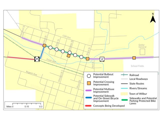
Zoomed out map view locating the Wilbur project limits.
State Route (SR) 21 and US 2 within Wilbur have been identified as needing their asphalt concrete pavement rehabilitated to preserve the roadway structure and the public investment in highways. The original scope of this project involved rehabilitating the existing pavement with a hot mix asphalt pavement and upgrading basic safety features within the project limits to maintain safe highway operations.
In 2022, Move Ahead Washington was passed by the Washington State Legislature, which included a requirement for WSDOT to incorporate principles of Complete Streets into transportation projects with an estimated budget greater than $500,000 and starting design on or after July 1, 2022. To aid in the implementation of this requirement, WSDOT established a Complete Streets process that first screens all programmed projects for Complete Streets applicability and subsequently provides a planning and conceptual design phase – known as pre-design – and target outcomes for projects that are required to incorporate Complete Streets. More information about the Complete Streets requirement and WSDOT’s implementation process is available on WSDOT’s Complete Streets page.
The Complete Streets screening process found the Wilbur paving project for US 2 and SR 21 to require implementation of the Complete Streets requirement. Complete Streets is expected to be implemented on US 2 from NW Portland St to the Dollar General Store and from NW Main Ave to SW Front Ave on SR 21. These extents may be adjusted as the project progresses. A pre-design phase has been initiated to conduct this analysis and identify the preferred Complete Streets implementation along and across the corridor. The pre-design phase includes the following tasks:
- Coordination with local and regional jurisdictions
- Identification of Complete Streets gaps and needs
- Community engagement
- Development and selection of preferred Complete Streets alternatives
- 30% design of preferred alternatives
- Documentation
Community engagement summary and results to date
The WSDOT project team enjoyed the opportunity to connect with the Wilbur community in several ways this past spring. We hosted a project booth at Wild Goose Bill Days on May 17, sent a community-wide mailer about the project, collected input through a Spring 2025 online survey, and hosted a public workshop on May 20. These efforts provided valuable insights into where and why people walk, bicycle, and roll along and across the corridors, including where they tend to avoid. Feedback received guided the development of the strategies being shared for further input.
The Public Workshop was held on Tuesday, May 20, 2025, from 5:00 p.m. to 6:30 p.m. at the Wilbur Community Center in the Auditorium. A total of 13 individuals participated in the workshop in person. There was a virtual Microsoft Teams option also available for those who could not attend in person. The primary goal was to inform attendees about the project and the Complete Streets approach, while also gathering input and insights. Key objectives included collecting feedback on preliminary concepts (such as different bike lane configurations), identifying priority intersections and crossings, learning about large truck traffic concerns, and understanding participants' experiences walking, bicycling, and rolling along and across the corridors.
More updates will be available later in September.